
GEOGRAPHIC INFORMATION SYSTEMS
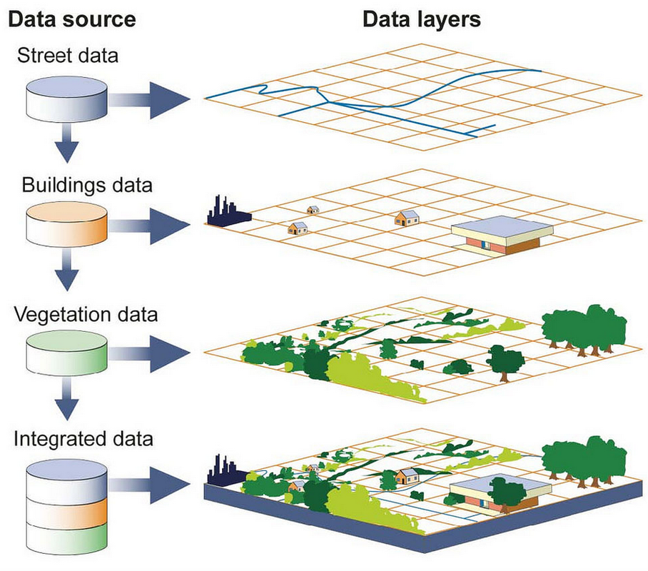
A WORLD IN 3DGeographic Information Systems are being used more as it permeates current modern technology.
Highly accurate Real Time Kinematic (RTK) GPS technologies are being integrated into equipment and vehicles which give accuracies up to 2cm when capturing location data. This allows for extremely accurate position points and lines to be made when surveying a site, before any construction begins. We are able to collect and edit a majority of digital geographic data including:
The following is just some of the software used to generate accurate maps for our customers.
|
|

|
Trimble Farmworks Surface |
|
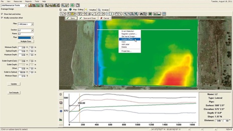
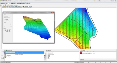
With Trimble Farmworks Surface software we have the ability to collect raw data by surveying the physical area first.
After the data has been collected it's processed by Surface to give us a topological data set where can view the following:
This allows us to save time with both accurate calculations and materials to ensure the necessary flow rates are correct.
|

|
QGIS Software Suite |
|
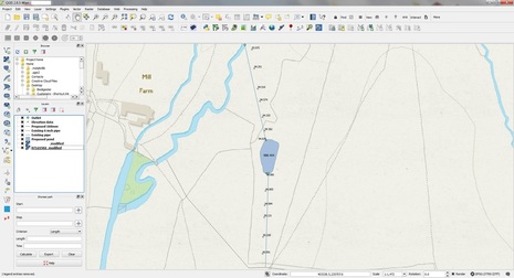
QGIS is used to create end user designs using the finalised Shapefiles taken from Farmworks. While Farmworks is great for calculating water flow and drainage using the elevation data, it can be a bit restrictive with how the data can be presented.
QGIS allows for a more flexible approach to be taken once pipe lengths and depths have been calculated correctly in Surface. This not only gives a much more clean and professional look but allows different types of data to be presented together on the same page. This prevents a glut of information which can over complicate plans, while still allowing pertinent information to be shown. |
|
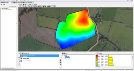
Basic elevation data loaded in to Farmworks after surveying the local area using GPS. The representation of the terrain elevation is show using a colour coded key.
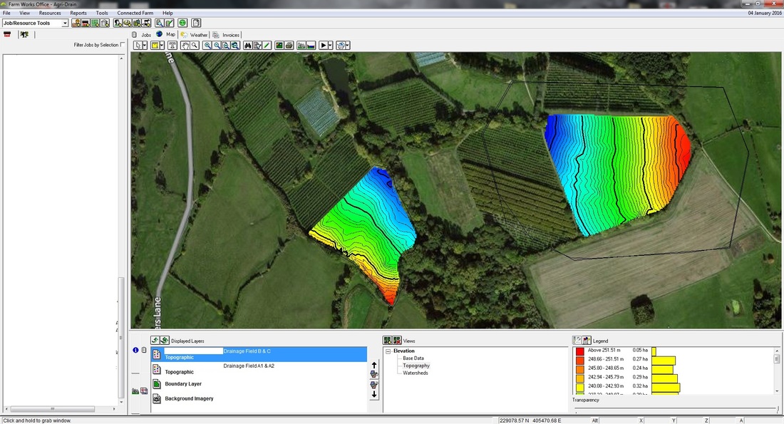
Contours at this point are added and other forms of local data are studied, revealing the lie of the land for the engineer to begin work with.
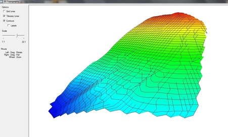
The 3D elevation data shows where tributary's are expected to flow underground and where they can be best taken advantage of when draining land.
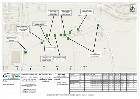
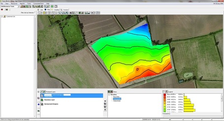
QGIS is then used after transferring the information created in Surface (pipe locations, types and lengths) creating clean end user maps for customers. Shown here is the proposal we send to customers with our quote.

|
The elevation data at this point is manipulated to make it easier to see potential problems with laying pipe lines; such as poor flow gradients, live flora and uneven grounds.
3D images of the area are generated and handed over for the engineer to begin calculating drainage pipe locations, removing the need for multiple visits to the site.
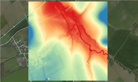
DEM models are also used to accurately check an maps elevation over far larger areas. Typically used in flood plain calculations when required.
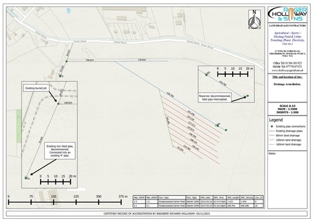
Another example of a final customer plan. Details about the customer and site are added here for reference, as well as more useful incarnations of the information being displayed.

|
LiDAR works by using a laser, analysing the reflected light and creating a 3D image based on what light is bounced back to the receiver unit. The the data density or "resolution" is far higher than a standard handheld GPS unit, allowing individuals to literally "see" the recorded data points as a image.
LAS files from LiDAR capable vehicles/aircraft can be imaged using our software. While this is still an emerging technology in the UK, surveying and construction firms are catching on at the ease which this can be deployed on sites, especially using autonomous aerial vehicles. In recent years, cameras to LiDAR units have all shrunk in size and weight allowing for these units to be placed on board said UAVs.
Already recognised for its accuracy, speed and the marked reduction in man hours, it is becoming a common component in the industry for collecting different forms of environmental data to study.
|
|


Abberley, Alvechurch, Bewdley, Birtsmorton, Bishampton, Bishops, Frome, Boraston, Bournheath, Bransford, Bredon, Bringsty, Broadway, Bromsgrove, Chaddesley Corbett, Charlton, Church Lench, Clent, Cleobury Mortimer, Clows Top, Colwall, Cookley, Defford, Droitwich, Droitwich Spa, Elcocks Brook, Evesham, Fladbury, Flyford Flavell, Great Malvern, Great Witley, Hagley, Hanley Castle, Hartlebury, Harvington, Hollywood, Honeybourne, Kemerton, Kempsey, Kidderminster, Kinlet, Knightwick,
Little Malvern, Malvern, Malvern Link, Malvern Wells, Martley, North Littleton, Offenham, Ombersley, Pensax, Pershore, Pinvin, Powick, Redditch, Sambourne, Severn Stoke, Shatterford, Shrawley, Smite, Stoke Bliss, Stoke Heath, Stoke Prior, Stottesdon, Stourbridge, Stourport On Severn, Tenbury Wells, Tewkesbury, Upton Upon Severn, Wadborough, Welland, Whitbourne, Wichenford, Willersley Hill, Winchenford, Worcester, Wyre Piddle, Wythall.
Little Malvern, Malvern, Malvern Link, Malvern Wells, Martley, North Littleton, Offenham, Ombersley, Pensax, Pershore, Pinvin, Powick, Redditch, Sambourne, Severn Stoke, Shatterford, Shrawley, Smite, Stoke Bliss, Stoke Heath, Stoke Prior, Stottesdon, Stourbridge, Stourport On Severn, Tenbury Wells, Tewkesbury, Upton Upon Severn, Wadborough, Welland, Whitbourne, Wichenford, Willersley Hill, Winchenford, Worcester, Wyre Piddle, Wythall.